Topic: Globe model of the Earth. Earth's axis shift
The Earth is constantly in motion, rotating around the Sun and around its own axis. This movement and the constant tilt of the Earth's axis (23.5°) determines many of the effects that we observe as normal phenomena: night and day (due to the rotation of the Earth on its axis), the change of seasons (due to the tilt of the Earth's axis), and different climate in different areas. Globes can be rotated and their axis is tilted like the Earth’s axis (23.5°), so with the help of a globe you can trace the movement of the Earth around its axis quite accurately, and with the help of the Earth-Sun system you can trace the movement of the Earth around the Sun.
Rotation of the Earth around its axis
 The Earth rotates on its own axis from west to east (counterclockwise when viewed from the North Pole). It takes the Earth 23 hours, 56 minutes, and 4.09 seconds to complete one full rotation on its own axis. Day and night are caused by the rotation of the Earth. The angular velocity of the Earth's rotation around its axis, or the angle through which any point on the Earth's surface rotates, is the same. It is 15 degrees in one hour. But the linear speed of rotation anywhere at the equator is approximately 1,669 kilometers per hour (464 m/s), decreasing to zero at the poles. For example, the rotation speed at latitude 30° is 1445 km/h (400 m/s).
We do not notice the rotation of the Earth for the simple reason that in parallel and simultaneously with us all objects around us move at the same speed and there are no “relative” movements of objects around us. If, for example, a ship moves uniformly, without acceleration or braking, through the sea in calm weather without waves on the surface of the water, we will not feel at all how such a ship is moving if we are in a cabin without a porthole, since all objects inside the cabin will be move parallel with us and the ship.
Movement of the Earth around the Sun
While the Earth rotates on its own axis, it also rotates around the Sun from west to east counterclockwise when viewed from the north pole. The earth needs one sidereal year(about 365.2564 days) to complete one full revolution around the Sun. The path of the Earth around the Sun is called the Earth's orbit and this orbit is not perfectly round. The average distance from the Earth to the Sun is approximately 150 million kilometers, and this distance varies up to 5 million kilometers, forming a small oval orbit (ellipse). The point in the Earth's orbit closest to the Sun is called Perihelion. The earth passes this point in early January. The point of the Earth's orbit farthest from the Sun is called Aphelion. The earth passes this point in early July.
Since our Earth moves around the Sun along an elliptical path, the speed along the orbit changes. In July, the speed is minimal (29.27 km/sec) and after passing aphelion (upper red dot in the animation) it begins to accelerate, and in January the speed is maximum (30.27 km/sec) and begins to slow down after passing perihelion (lower red dot ).
While the Earth makes one revolution around the Sun, it covers a distance equal to 942 million kilometers in 365 days, 6 hours, 9 minutes and 9.5 seconds, that is, we rush along with the Earth around the Sun at an average speed of 30 km per second (or 107,460 km per hour), and at the same time the Earth rotates around its own axis once every 24 hours (365 times per year).
In fact, if we consider the movement of the Earth more scrupulously, it is much more complex, since the Earth is influenced by various factors: the rotation of the Moon around the Earth, the attraction of other planets and stars.
Questions before a paragraph
1. Why is the axis of the school globe inclined to the horizontal stand at an angle of 66.5 degrees?
The Earth globe is an accurate model of the planet. All geographical objects are depicted on the globe. The axis of the globe is inclined to its horizontal stand at 66.5 degrees due to the fact that the earth's axis is also inclined at the same angle. Thus, the globe not only gives an idea of what the planet looks like, but also gives an idea of its overall location in outer space.
2. How is the earth's axis oriented? What star is it pointed at?
The earth's axis is tilted relative to a straight line. The fact that the Earth's axis is not strictly vertical has a very great importance for the planet. It is reliably known that with its north pole our planet is directed towards North Star. That is why people use it to determine the northern direction at night.
3. What methods do cartographers use to depict the relief of the earth’s surface on the globe and maps?
On a globe, relief shapes are depicted as isohypses. If horizontal lines are drawn at equal distances, then isohypses are drawn in accordance with the scale: 200, 500, 1000, 1500, 2000, 3000 and then after 1000 m. The relief images are supplemented with layer-by-layer coloring. The scale of heights and depths helps characterize the relief of land and seabed on the globe. The scale is divided into levels of heights and depths. Using the height and depth scale, you can more accurately determine the height or depth in meters. Higher land areas are colored brown. Color saturation increases with increasing height. Unlike topographic maps, green color on the globe they are used to show plains rather than vegetation.
The underwater relief and depths of various parts of the oceans and seas are indicated on the globe by isobaths. Isopaths are lines connecting points of the bottom with the same depth. Various shades are used for layer-by-layer coloring of depths of blue color: the deeper, the darker.
Questions and tasks
1. Using the globe, determine which level of the altitude scale the topography of your area corresponds to.
The height scale is a scale of different color ranges. The so-called high-altitude stage has its own color. As a rule, low-lying areas are green (0 - 200m). The steps above (200m and above) are painted yellow, then brown. The higher the dot, the darker the colors. It also happens the other way around. The mountains are light yellow, and the sea depressions are dark blue. Typically, the height scale is used on geographical maps, as well as hypsometric and physical maps. An elevation scale is placed in the margins of the map.
Relief Southern Urals has great variety. It was formed over millions of years. Within Chelyabinsk region available various shapes relief - from lowlands and hilly plains to ridges whose peaks exceed 1000 m.
The West Siberian Lowland is limited from the west by a horizontal line (elevation 190 m above sea level), which passes through the villages of Bagaryak, Kunashak and further through Chelyabinsk to the south. The lowland slopes slightly to the northeast, dropping to 130 m at the eastern border of the region.
2. Using a flexible ruler, determine the distance from your settlement before largest cities world, for example Mexico City, New York, Tokyo, Rio de Janeiro.
Distance from Chelyabinsk to Rio de Janeiro - 13000; Mexico City - 11500; New York - 8500; Tokyo – 6100 kilometers.
3. Determine the extent of Russian territory from west to east along the Arctic Circle.
It is known that the length of one degree is 44.5 km and the Arctic Circle crosses the borders of Russia at approximately longitude 29 degrees. in the west and 171gr. in the east (180 - 29) + 9 = 160gr, 160 *44.5km=7120 km.
The shortest distance from the western border with the United States is in the Bering Strait.
The western point on the border with Finland has coordinates -67*n. w. and 32 * in. d.. Distance to the Greenwich meridian = 180 * -32 * = 148 *, and also add 11 * to 169 * W. d, to the border with America and we get the total distance in degrees = 148 + 11 = 159 *. Each degree at the 67th parallel = 52 km, which means the shortest distance along the 67th parallel will be 52 km * 161 * = 8372 km. (approximate value)
4. Determine the extent of the territory of Russia from north to south along the meridian of 45 degrees east.
To find the extent of Russia from north to south, look at the coordinates of north and south along the 45 * meridian. The northern point lies at 68*N, and in the south at 40*N. We find the difference 68*-40*=28*, 111.1*28= 3110 km
“Bears rub their backs against the earth’s axis,” says one famous song... and about the American folk hero Davy Crocket is even told that he once fixed the earth's axis! Of course, the difference between poetically and reality is clear to everyone, and it would not occur to anyone to imagine the earth’s axis in the form of some kind of stick - such as the axis of a wheel or a globe - on which the planet is strung. However, the old song is right about one thing: the earth’s axis - this imaginary line around which the Earth rotates - really passes “somewhere in this world, where it is always frosty,” i.e. through the North and South Poles of the Earth.
Everyone who has seen the globe has noticed that the axis on which it is strung does not stand vertically, but is somewhat inclined. This reflects real situation case - the Earth's axis is actually tilted relative to an imaginary vertical line perpendicular to the orbital plane by 23.5 degrees. Why did it happen?
Scientists believe that at the dawn of life solar system there were much more planets in it than now, and most of them moved in catastrophic orbits - i.e. such that collisions were inevitable. Our Mother Earth also got it. She was luckier than many other planets - she survived, but some consequences of large collisions do occur. And this is not only the presence of a satellite, but also the tilt of the rotation axis. It must be said that the Earth, with its 23.5 degrees, is still lucky - as a result of such collisions with large objects, Uranus generally “fell on its side”, its axis deviates by 98 degrees! It turns towards the Sun, now with one pole, now with the other, now with moderate latitudes, now with the equator...
But let's return to our Earth. Is this axis tilt good or bad? As practice shows, the question is not so clear-cut... one day I came across a website on the Internet, the creators of which, on behalf of a certain highly developed civilization promised to “correct” the tilt of the Earth’s axis (I didn’t read further, so I don’t know how much money they asked for this)... by “correcting”, obviously, they meant eliminating the tilt - i.e. As a result of this grandiose project, the axis was supposed to stand vertically, perpendicular to the orbital plane. What would happen then?
First of all, our seasons would disappear. After all, it is thanks to the tilt of the earth's axis that the northern and southern hemispheres alternately receive more or less energy from the Sun. Of course, there would still be temperature changes throughout the year, because the Earth’s orbit is not perfectly round, but elliptical, the Earth either approaches the Sun or moves away from it - but this could not be called seasons, by and large - the temperature on the planet was would be relatively stable... which?
In temperate latitudes - somewhere at the level of our September or March - so farming would hardly be possible. At the poles there would be no polar day and polar night - but there would be an eternal “polar early morning" Perhaps, due to constant heating, the polar climate would be a little less harsh than it is, however, according to other calculations, it would be impossible to live at all in areas close to the poles (somewhere in the Scandinavia region). In general, nothing good.
Or maybe those “enthusiasts” wanted, on the contrary, to tilt the Earth’s axis more – by 45 degrees, for example? Then, perhaps, the climate will improve in the polar regions - but this will bring little joy to the rest of the Earth: the ice will begin to melt en masse! One can only guess how many territories will be flooded. Hot climate zone will cease to be hot - it will become moderate - and the moderate will join the cold. In the middle zone and in the south of Russia and even in Ukraine there will be polar days and polar nights... in general, I don’t want to implement this project.
It is better to leave the Earth’s axis as it is... especially since it still does not “stand still”. We have all seen a rotating top - its axis does not stand vertically in one position, but constantly describes a circle, this is called precession. So, the same thing happens with the Earth’s rotation axis. This causes periodic climate changes (named after the discoverer, they are called Milankovitch cycles), but they cannot affect our lives - after all, the duration of such a cycle is 25,800 years! However, the precession could be greater - in this case, the difference in temperature between the hemispheres would be colossal, which would give rise to monstrous hurricanes... of course, one can imagine living organisms that could adapt to such conditions, but the trouble is that They wouldn’t have time to adapt: the climate would change so quickly that evolution wouldn’t keep up! So we can only be glad once again that our axis of rotation is exactly like this... the Moon provides us with such precession, so if we seriously start looking for a planet to move to, we will definitely need to ask if it has a satellite comparable to our Moon.
However, we still manage to feel some manifestations of precession – on the scale of history, of course. It is because of the precession of the earth's axis starry sky now it does not look quite the same as the Babylonian sages saw it - and the sectors of the zodiacal belt no longer quite correspond to the zodiacal constellations. Therefore, voices are increasingly being heard that all horoscopes should be rewritten. However, it is hardly worth doing this: a horoscope - no matter how you draw it up - still extremely rarely corresponds to reality.
While looking through Yandex images for the query “18th century globe” I came across this photo. I started watching following a tip from the article “What if the Earth’s tilt was 45 degrees? » - the specified request produces globes in which the inclination of the earth's axis to the ecliptic is 45 degrees.
This is amazing: it is very difficult to believe that the earth’s axis could change its orientation in space: the earth is a big gyroscope, in common parlance - a top, with a huge moment of inertia, and it was impossible, as I thought, to turn it.
But you can’t argue with the facts: by historical standards, quite recently a huge catastrophe occurred, which nowhere in official version history is not reflected.
The process of reorientation of the Earth was also accompanied by a pole shift - the lithosphere “floated away,” so that the pole from the north of Greenland moved to the Arctic Ocean, where it remains (for now?) to this day.
If the earth's axis were inclined to the orbital plane by 45°
Let's now mentally make another change: let's give the earth's axis a tilt of half a right angle.
At the time of the equinoxes (around March 21 and around September 23), the cycle of days and nights on Earth will be the same as now.
But in June the Sun will be at its zenith at the 45th parallel (and not at 23.5°): this latitude would play the role of the tropics. At the latitude of Leningrad (60°), the Sun would not reach the zenith by only 15°; The height of the sun is truly tropical!
The hot zone would be directly adjacent to the cold one, and the moderate would not exist at all.
In Moscow and Kharkov, a continuous, sunsetless day would reign throughout June.
In winter, on the contrary, the continuous polar night would last for entire decades in Moscow, Kyiv, Kharkov, Poltava.
At this time, the hot zone would turn into a moderate one, because the Sun would rise there at noon no higher than 45°.
The tropical zone, of course, would lose a lot from this change, as well as the temperate one.
The polar region would gain something this time too: here, after a very severe (severe than now) winter, a moderately warm winter would begin. summer period, when even at the pole itself the Sun would stand at noon at an altitude of 45° and would shine for more than six months. Eternal ice The Arctic would noticeably yield to friendly action sun rays.
With such an inclination of the earth's spine, Greenland would definitely be “Grunland” - a green country, because a multi-month day, a six-month summer with the Sun above the horizon as it is now in central Russia would melt the snow that fell during the winter and night within a few days.
The recent position of the earth's axis also explains tropical vegetation in permafrost of the modern Arctic and heating systems not originally envisaged in the palaces of St. Petersburg and its environs.
In fact this fact- the key to unraveling almost everything that has been discovered by alternative scientists lately.
We can firmly say: modern history, deeper than the end of the 19th century - a complete falsification, a set of political myths compiled to please those who divided the globe.
Additionally
A comment, which was added to the repost of this article by the author http://stariy-khren.livejournal.com/
Let me make one small comment about your material.
On such globes, about which we're talking about, if you pay attention, there are two round scale frames - one is horizontal (on the “table”), and the second (the one in which the globe axis is directly fixed) is vertical. And on both of them there are some “incomprehensible” symbols... There are similar symbols on the globe itself...
And the whole point is that earlier globes were used not for interior decoration, but directly for navigation - they were used to determine their current location at sea and the azimuths of the directions of movement.
In such globes, the meridian vertical frame (“observer meridian”) is movable; it rotates in the grooves along with the globe and changes the inclination of its axis. It was set daily so that at the current moment in time the point where the ship (i.e., the observer) was located was exactly at the zenith - at the “top” of the globe. Those. the inclination of the axis was set so that the position of the zenith corresponded to the current latitude of the place, determined by the astrolabe or sextant.
In this position of the globe, the horizontal ring (“true horizon”) is aligned with the actual local horizon and allows you to count the directions. The more accurately both scales are calibrated, the more accurate the location coordinates.
The equator, ecliptic, equinox points, etc. are marked on the globe itself.
Both of these scale systems give the right ascensions of the luminaries, and for the reference at the equator at the observer's meridian ring - local sidereal time. The Aries point (at the intersection of the equator and ecliptic) was traditionally marked with the number XXIV hours (360°). The opposite is the Libra point number XII (180°). The ecliptic on the globe itself is always drawn at an angle of 23.5° to the equator and is divided into 12 segments, graduated from 0 to 30°.
These systems of movable and fixed scales on the globe and frames made it possible (without very complex recalculations), by mechanically comparing equatorial coordinates with ecliptic ones, to use simple tables of the ascension of landmark stars to find the current coordinate.
A globe is a practical measuring device for navigation that allows you to “put” a map of the area under your current position. They looked not where Amsterdam or London was located, but where in this moment where your ship is and what is nearby - what shores and continents.
Maps were also built with the help of such globes - marks were first applied directly to the globe itself as it was opened coastline(they marked the current position of his “top of the head”), and only then, at the end of the expedition, they transferred the coordinates to a map with monograms, angels and sea monsters...
It could also be used directly geographical maps, but then to recalculate equatorial and ecliptic coordinates they used a globe of the same design, but with an image not of the earth, but of the starry sky - with constellations and landmark stars. This made it possible to avoid tables when finding coordinates, but required “removing” the coordinates from the globe and transferring them through the tables to the map.
Such star globes are used in the fleet as backup equipment (in case of failure modern systems navigation) are still used today. And the rules for handling them are taught in any sailing ship.
When navigating around the globe, you do not need an accurate marine chronometer, but any watch that provides local time within one day is sufficient - i.e. a banal clepsydra, synchronized daily at noon, or a set of hourglass(usually hourly, half-hourly and half-minute). By the way, you don’t need a compass either...7 ratings
Our planet is constantly in motion:
- rotation around its own axis, movement around the Sun;
- rotation with the Sun around the center of our galaxy;
- movement relative to the center of the Local Group of galaxies and others.
Movement of the Earth around its own axis
Rotation of the Earth around its axis(Fig. 1). The earth's axis is taken to be an imaginary line around which it rotates. This axis is deviated by 23°27" from the perpendicular to the ecliptic plane. The Earth's axis intersects with the Earth's surface at two points - the poles - North and South. When viewed from the North Pole, the Earth's rotation occurs counterclockwise, or, as is commonly believed, with west to east. The planet completes a full rotation around its axis in one day.
Rice. 1. Rotation of the Earth around its axis
A day is a unit of time. There are sidereal and solar days.
Sidereal day- this is the period of time during which the Earth will turn around its axis in relation to the stars. They are equal to 23 hours 56 minutes 4 seconds.
Sunny day- this is the period of time during which the Earth turns around its axis in relation to the Sun.
The angle of rotation of our planet around its axis is the same at all latitudes. In one hour, each point on the Earth's surface moves 15° from its original position. But at the same time, the speed of movement is inversely proportional to geographical latitude: at the equator it is 464 m/s, and at a latitude of 65° it is only 195 m/s.
The rotation of the Earth around its axis in 1851 was proved in his experiment by J. Foucault. In Paris, in the Pantheon, a pendulum was hung under the dome, and under it a circle with divisions. With each subsequent movement, the pendulum ended up on new divisions. This can only happen if the surface of the Earth under the pendulum rotates. The position of the pendulum's swing plane at the equator does not change, because the plane coincides with the meridian. The Earth's axial rotation has important geographical consequences.
When the Earth rotates, centrifugal force arises, which plays an important role in shaping the shape of the planet and reduces the force of gravity.
Another of the most important consequences of axial rotation is the formation of a rotational force - Coriolis forces. In the 19th century it was first calculated by a French scientist in the field of mechanics G. Coriolis (1792-1843). This is one of the inertia forces introduced to take into account the influence of rotation of a moving frame of reference on the relative motion of a material point. Its effect can be briefly expressed as follows: every moving body in the Northern Hemisphere is deflected to the right, and in the Southern Hemisphere - to the left. At the equator, the Coriolis force is zero (Fig. 3).

Rice. 3. Action of the Coriolis force
The action of the Coriolis force extends to many phenomena of the geographical envelope. Its deflecting effect is especially noticeable in the direction of movement of air masses. Under the influence of the deflecting force of the Earth's rotation, the winds of temperate latitudes of both hemispheres take a predominantly western direction, and in tropical latitudes - eastern. A similar manifestation of the Coriolis force is found in the direction of movement of ocean waters. The asymmetry of river valleys is also associated with this force (the right bank is usually high in the Northern Hemisphere, and the left bank in the Southern Hemisphere).
The rotation of the Earth around its axis also leads to the movement of solar illumination across the earth's surface from east to west, i.e., to the change of day and night.
The change of day and night creates a daily rhythm in living and inanimate nature. The circadian rhythm is closely related to light and temperature conditions. The daily variation of temperature, day and night breezes, etc. are well known. Circadian rhythms also occur in living nature - photosynthesis is possible only during the day, most plants open their flowers in different watches; Some animals are active during the day, others at night. Human life also flows in a circadian rhythm.
Another consequence of the Earth’s rotation around its axis is the time difference at different points on our planet.
Since 1884, zone time was adopted, that is, the entire surface of the Earth was divided into 24 time zones of 15° each. Behind standard time take the local time of the middle meridian of each zone. Time in neighboring time zones differs by one hour. The boundaries of the belts are drawn taking into account political, administrative and economic boundaries.
The zero belt is considered to be the Greenwich belt (named after the Greenwich Observatory near London), which runs on both sides of the prime meridian. The time of the prime, or prime, meridian is considered Universal time.
Meridian 180° is taken as international date line— conditional line on the surface globe, on both sides of which the hours and minutes coincide, and the calendar dates differ by one day.
For more rational use in the summer of daylight in 1930, our country introduced maternity time, one hour ahead of the time zone. To achieve this, the clock hands were moved forward one hour. In this regard, Moscow, being in the second time zone, lives according to the time of the third time zone.
Since 1981, from April to October, time has been moved forward one hour. This is the so called summer time. It is introduced to save energy. In summer, Moscow is two hours ahead of standard time.
The time of the time zone in which Moscow is located is Moscow.
Movement of the Earth around the Sun
Rotating around its axis, the Earth simultaneously moves around the Sun, going around the circle in 365 days 5 hours 48 minutes 46 seconds. This period is called astronomical year. For convenience, it is believed that there are 365 days in a year, and every four years, when 24 hours out of six hours “accumulate”, there are not 365, but 366 days in a year. This year is called leap year and one day is added to February.
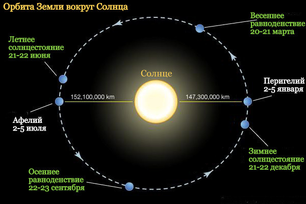
The path in space along which the Earth moves around the Sun is called orbit(Fig. 4). The Earth's orbit is elliptical, so the distance from the Earth to the Sun is not constant. When the Earth is in perihelion(from Greek peri- near, near and helios- Sun) - the point of orbit closest to the Sun - on January 3, the distance is 147 million km. It is winter in the Northern Hemisphere at this time. Greatest distance from the Sun in aphelion(from Greek aro- away from and helios- Sun) - greatest distance from the Sun - July 5th. It is equal to 152 million km. It's summer in the Northern Hemisphere at this time.

Rice. 4. The movement of the Earth around the Sun
The annual movement of the Earth around the Sun is observed by the continuous change in the position of the Sun in the sky - the midday altitude of the Sun and the position of its sunrise and sunset change, the duration of the light and dark parts of the day changes.
When moving in orbit, the direction of the earth's axis does not change; it is always directed towards the North Star.
As a result of changes in the distance from the Earth to the Sun, as well as due to the inclination of the Earth's axis to the plane of its movement around the Sun, an uneven distribution of solar radiation is observed on Earth throughout the year. This is how the change of seasons occurs, which is characteristic of all planets whose axis of rotation is tilted to the plane of its orbit. (ecliptic) different from 90°. The orbital speed of the planet in the Northern Hemisphere is higher in winter and lower in summer. Therefore, the winter half-year lasts 179 days, and the summer half-year - 186 days.
As a result of the Earth's movement around the Sun and the tilt of the Earth's axis to the plane of its orbit by 66.5°, our planet experiences not only a change of seasons, but also a change in the length of day and night.
The rotation of the Earth around the Sun and the change of seasons on Earth are shown in Fig. 81 (equinoxes and solstices in accordance with the seasons in the Northern Hemisphere).
Only twice a year - on the days of the equinox, the length of day and night throughout the Earth is almost the same.
Equinox- the moment in time at which the center of the Sun, during its apparent annual movement along the ecliptic, crosses the celestial equator. There are spring and autumn equinoxes.
The tilt of the Earth's rotation axis around the Sun on the days of the equinoxes March 20-21 and September 22-23 turns out to be neutral with respect to the Sun, and the parts of the planet facing it are evenly illuminated from pole to pole (Fig. 5). The sun's rays fall vertically at the equator.
The longest day and the longest short night observed per day summer solstice.

Rice. 5. Illumination of the Earth by the Sun on the days of the equinox
Solstice- the moment the center of the Sun passes the points of the ecliptic most distant from the equator (solstice points). There are summer and winter solstices.
On the day of the summer solstice, June 21-22, the Earth occupies a position in which north end its axis is tilted towards the Sun. And the rays fall vertically not on the equator, but on the northern tropic, the latitude of which is 23°27". Not only the polar regions are illuminated around the clock, but also the space beyond them up to a latitude of 66°33" (the Arctic Circle). In the Southern Hemisphere at this time, only that part of it that lies between the equator and the southern Arctic Circle (66°33") is illuminated. Beyond it, the earth's surface is not illuminated on this day.
On the day of the winter solstice, December 21-22, everything happens the other way around (Fig. 6). The sun's rays are already falling vertically on the southern tropics. The areas that are illuminated in the Southern Hemisphere are those lying not only between the equator and the tropics, but also around South Pole. This situation continues until the day spring equinox.

Rice. 6. Illumination of the Earth on the winter solstice
On two parallels of the Earth on solstice days, the Sun at noon is directly above the observer’s head, i.e. at the zenith. Such parallels are called the tropics. In the Northern Tropic (23° N) the Sun is at its zenith on June 22, in the Southern Tropic (23° S) - on December 22.
At the equator, day is always equal to night. The angle of incidence of the sun's rays on the earth's surface and the length of the day there change little, so the change of seasons is not pronounced.
Arctic Circles remarkable in that they are the boundaries of areas where there are polar days and nights.
Polar day- the period when the Sun does not fall below the horizon. The farther the pole is from the Arctic Circle, the longer the polar day. At the latitude of the Arctic Circle (66.5°) it lasts only one day, and at the pole - 189 days. In the Northern Hemisphere, at the latitude of the Arctic Circle, the polar day is observed on June 22, the day of the summer solstice, and in the Southern Hemisphere, at the latitude of the Southern Arctic Circle, on December 22.
polar night lasts from one day at the latitude of the Arctic Circle to 176 days at the poles. During the polar night, the Sun does not appear above the horizon. In the Northern Hemisphere at the latitude of the Arctic Circle, this phenomenon is observed on December 22.
It is impossible not to note this miraculous phenomenon nature, like white nights. White Nights- these are bright nights at the beginning of summer, when the evening dawn converges with the morning and twilight lasts all night. They are observed in both hemispheres at latitudes exceeding 60°, when the center of the Sun at midnight falls below the horizon by no more than 7°. In St. Petersburg (about 60° N) white nights last from June 11 to July 2, in Arkhangelsk (64° N) - from May 13 to July 30.
The seasonal rhythm in connection with the annual movement primarily affects the illumination of the earth's surface. Depending on the change in the height of the Sun above the horizon on Earth, there are five lighting zones. The hot zone lies between the Northern and Southern tropics (Tropic of Cancer and Tropic of Capricorn), occupies 40% of the earth's surface and differs the largest number heat coming from the Sun. Between the tropics and the Arctic Circles in the Southern and Northern Hemispheres there are moderate light zones. The seasons of the year are already expressed here: the further from the tropics, the shorter and cooler the summer, the longer and colder winter. Polar belts in the North and Southern Hemispheres limited to the Arctic Circles. Here the height of the Sun above the horizon is low throughout the year, so the amount of solar heat is minimal. The polar zones are characterized by polar days and nights.
Depending on the annual movement of the Earth around the Sun, not only the change of seasons and the associated unevenness of illumination of the earth’s surface across latitudes, but also a significant part of the processes in the geographical envelope: seasonal changes in weather, the regime of rivers and lakes, rhythms in the life of plants and animals, types and timing of agricultural work.
Calendar.Calendar- a system for calculating long periods of time. This system is based on periodic natural phenomena associated with the movement of celestial bodies. The calendar uses astronomical phenomena - the change of seasons, day and night, change lunar phases. The first calendar was Egyptian, created in the 4th century. BC e. On January 1, 45, Julius Caesar introduced Julian calendar, which is still used by Russian Orthodox Church. Due to the fact that the length of the Julian year is 11 minutes 14 seconds longer than the astronomical one, by the 16th century. an “error” of 10 days accumulated - the day of the vernal equinox did not occur on March 21, but on March 11. This error was corrected in 1582 by decree of Pope Gregory XIII. The counting of days was moved forward 10 days, and the day after October 4 was prescribed to be considered Friday, but not October 5, but October 15. The vernal equinox was again returned to March 21, and the calendar began to be called the Gregorian calendar. It was introduced in Russia in 1918. However, it also has a number of disadvantages: unequal length of months (28, 29, 30, 31 days), inequality of quarters (90, 91, 92 days), inconsistency of the numbers of months by day of the week.


- Russia is a multinational state We live in a multinational country
- The smallest peoples of the world Which group of peoples is the smallest
- How to change a cash receipt order in 1c
- Penalty calculation at the refinancing rate, penalty online
- Other current assets on the balance sheet are... Accounts and other assets
- Procedure for submitting calculations for insurance premiums Calculation of RSV for 9 months
- How to reduce VAT and maintain profits
- International accounting and reporting standards
- How to fill out a tax return correctly
- Crab salad with cheese - five best recipes
- Cutlets in foil in the oven
- Management project based on the example of an enterprise presentation
- Abstract: Elementary particles
- Presentation on the topic "management"
- History of the development of computer technology presentation for a lesson on the topic Historical development of computer technology presentation
- Astronomy Presentations Interesting Topics for Astronomy Presentations
- Presentation on history "counting years in history"
- Astronomy Presentations Astronomy Presentation Template
- The anniversary of the expulsion of the Karachais recalled the problem of rehabilitation of repressed peoples
- Udmurt people What peoples live on the territory of Udmurtia