Earthquake in Chile - natural disasters. Earthquake in Chile (1960)
The 1960 Valdivia earthquake or Great Chilean earthquake of May 22, 1960 is the strongest earthquake ever recorded. Its strength is estimated at 9.5M. It occurred during the day and the resulting tsunami hit the southern coast of Chile, Hawaii, Japan, the Philippines, eastern New Zealand and the Aleutian Islands in Alaska.
The epicenter of the earthquake was located near the Chilean city of Valdivia, approximately 700 kilometers south of Santiago. The local tsunamis it caused, the height of which reached 25 meters, hit the Chilean coast. The major tsunami crossed the Pacific Ocean and devastated Hilo, Hawaii. Waves up to 10.7 meters high were recorded 10,000 kilometers from the epicenter - in Japan and the Philippines.
It is impossible to accurately determine the number of deaths and the extent of material damage caused by a natural disaster of this scale. Various estimates of the total death toll from the earthquake and tsunami are given in a USGS (United States Geological Survey) work citing 2231, 3000, or 5700 deaths; another source puts the death toll at 6000. material damage- from 400 to 800 million US dollars in 1960 (or from 2.6 to 5.2 billion US dollars in 2005, taking into account inflation).
The Great Chilean Earthquake was preceded by a smaller earthquake in the province of Arauco at 06:02 on May 21, 1960. Communications with southern Chile were cut off, and President George Alessanri was forced to cancel the traditional holiday ceremony at the Battle of Iquique memorial in order to take charge of emergency measures to providing assistance to victims. The government had just begun organizing rescue operations in the affected areas when the second earthquake struck Valdivia at 2:55 p.m. local time on May 22.
The second earthquake affected the territory of Chile between Talca and the island of Chiloe, an area of more than 400,000 square kilometers. Coastal villages like Tolten simply disappeared. At Coral, Valdivia's main port, sea levels rose 4 meters before they began to recede. At 16-20 an eight-meter wave hit the Chilean coast, mainly between Concepcion and Chiloe. Ten minutes later, reports of another wave 10 meters high were received. By the time the tsunami hit, reports of hundreds of deaths had already arrived. It was ruled a large number of ships on land - the release reached 150 meters.
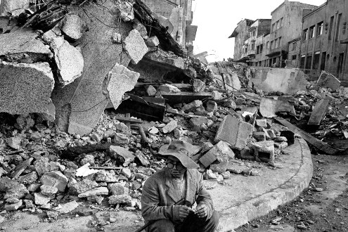
The tsunami generated also affected other continents (Fig. 8)
Rice. 8
Many forts around Valdivia, built during colonial Spain, were completely destroyed. In addition, the subsidence of the earth's surface has destroyed buildings, deepened local rivers and created swamps in places such as Rio Cruz and Chorocomayo. A significant part of the city was flooded. Valdivia's electrical system and water supply were completely destroyed.
Despite heavy rains on May 21, the city remained without water supply. The water in the river was brown from landslide sediments and was full of floating debris, among which were entire wooden houses. Residents of the rainiest part of Chile suffered from a lack of drinking water.
Two days after the earthquake, the Cordon Caulle volcano began to erupt. It is possible that other volcanoes also began to erupt, but at that time, due to disrupted communications, other eruptions were not recorded. The relatively low death toll in Chile (estimated at a maximum of 6,000) can be partly explained by the fact that many people were in churches at the time of the earthquake. Churches are usually built on a more secure foundation than most residential buildings. Coastal cities were also located quite high above sea level, following the pre-Hispanic tradition of urban planning.
On the evening of April 1, 2014, a powerful earthquake (8.2 on the Richter scale) occurred in northern Chile, near the city of Iquique, resulting in a tsunami that hit the coast with seven-foot waves. Fires broke out in several places, buildings and cars were damaged. According to the latest data, six people died, over 900 thousand local residents were evacuated.
 People try to catch a car on the highway between the cities of Iquique and Alto Hospicio.
Jeffrey invited his family to unwind a little from sad thoughts and visit Holland, look at the extraordinary beauty of medieval castles.
 People gathered for top floor residential building located just a few blocks from the coast. Having taken the most necessary things, local residents hastened to take refuge here before the powerful tsunami began.
 People flee the Costa Verde Bay after warnings of a tsunami heading towards them. Photo taken in Lima, Peru, April 1, 2014.
 Women wheel a child in a grocery basket as they leave their homes in Iquique. An 8.2 magnitude earthquake struck the northern coast of Chile on Wednesday evening, causing widespread damage and killing six people.
 Locals gather on the street after warning of a natural disaster. The photo was taken near the Pacific coast in Antofagasta.
 Firefighters battle fires that have engulfed residential buildings after an earthquake struck.
 A man films on camera the damage to his car, which ended up under the rubble of a destroyed building.
 Wrecked cars and boats litter the coastline of Iquique on April 2, 2014.
 People are sitting on the street, having left their homes for safety.
 Young people take pictures of a crack that has formed on the road. The photo was taken in Iquique on April 2, 2014, the day after a powerful 8.2-magnitude earthquake.
 Rescuers inspect a car damaged by a landslide.
 Completely destroyed or severely damaged residential buildings in Iquique as a result of the earthquake.
 The fishing boats were washed ashore by the resulting tsunami. Chile, Caleta Riquelme.
 A local fisherman is trying to save his boat, which sank as a result of the tsunami that arose against the backdrop of a powerful earthquake.
 A chair sits in the middle of a street in a heavily flooded area of Chile.
 A woman looks at a destroyed brick building located not far from her home.
 People are queuing for fuel. Photo taken at Riquelme Cove on April 2, 2014.
 Soldiers gesture to drivers, controlling the movement of vehicles.
 Special tape was used to fence off dangerous areas in some neighborhoods that suffered extensive damage from the elements.
 People line up at the market to buy consumable building materials for the restoration of their homes.
 Residents of the town of Pozo al Monte, located near the city of Iquique, are preparing to spend the night under open air on the football field.
 Police patrol on the streets of Chile. On the streets you can see a large crowd of people affected by the powerful earthquake and subsequent tsunami.
 An elderly woman is evacuated to a shelter for disaster victims. Photo taken north of Santiago, on the south coast Pacific Ocean, April 1.
 Fishermen inspect a boat thrown out onto the stands.
 A woman walks past a building destroyed by a terrible earthquake (8.2 on the Richter scale). Photo taken in Iquique, Northern Chile, April 2, 2014. More than 900 thousand residents fled to other coastal areas, according to the latest data, six people died.
 People park their cars and set up temporary tents on higher ground, away from the coast.
 People sleep in the open air, moving to higher areas away from the Pacific coast and fearing new tremors.
 A man clears the rubble near his house. Arica, Chile, April 2.
 People are gradually returning to their homes after spending the night in a tent camp. The photo was taken in the city of Arica. More than 900 thousand residents fled as a result of the terrible natural disaster to the coastal regions of Chile.
 Residents fled their unsafe homes. They warm themselves by the fire, settling down for the night right on the street.
 A local fisherman takes a nap on a jumble of fishing nets in Lima, Peru.
 The rubble is being cleared using heavy equipment. Photo taken on the road leading to the city of Camarones, Arica, April 3, 2014.
 People spend the night on the football field after strong earthquake in Arica.
 A woman gets drinking water outside the main grocery store in Iquique, 1,950 kilometers north of Santiago. Large supermarkets and gas stations are under police and military control.
 New cars remain parked on a hillside next to the Duty Free Zone (ZOFRI) in Iquique.
 Fishing boats damaged by the tsunami.
A series of tremors with a maximum magnitude of 7.2 occurred on March 11, 2010 in Chile, causing a tsunami threat.
The tremors were recorded at 11:39 local time (17:39 Moscow time). According to updated data, the epicenter of the earthquake was located 150 kilometers southwest of the country's capital, Santiago. The source of the earthquake was at a depth of 35 kilometers. Tremors were felt in several cities in the central part of the country, including Santiago and Valparaiso.
Characteristics of an earthquake
Main push parameters:
epicenter - near the coast of Chile, 35.909°S, 72.733°W;
time - 06:34:14 UTC;
magnitude - 8.8;
the depth of the source is 35 km.
Aftershocks and other earthquakes
20 minutes after the main impact, a follow-up shock with a magnitude of just over 6 on the Richter scale was recorded. An hour after the main impact, two more shocks with a magnitude of 5.4 and 5.6 were recorded. Two new tremors were recorded off the coast of Chile a few hours after an almost 9-magnitude earthquake. Their magnitudes were 6.9 and 5.4. They occurred approximately an hour apart and in the same area as the first earthquake.
Two new earthquakes occurred on March 3. The strength of the tremors was 5.9 and 6.3 on the Richter scale, respectively, according to the US Geological Survey. The tremors were recorded at a depth of 31 kilometers, 50 kilometers north of the city of Concepcion.
Three tremors were recorded on March 11 at 11:39 local time (17:39 Moscow time). The epicenter of the earthquake was located 150 kilometers southwest of the country's capital, Santiago, and the source of the disaster was at a depth of 35 kilometers. According to Agence France-Presse, tremors were felt in several cities in the central part of the country, including Santiago and Valparaiso. The tremors occurred just a few minutes before the swearing in of the country's new president, Sebastian Piñera, in Valparaiso.
One earthquake was recorded on March 13 at 07:34:42 (13:34 Moscow time) with a magnitude of 5.7.
Earthquake power
The magnitude 8.8 earthquake that occurred on February 27 in Chile may have shortened the length of the Earth's day. A laboratory researcher came to this conclusion jet propulsion NASA Richard Gross. The scientist calculated how the Earth's rotation should have changed as a result of tremors in Chile. Using a complex model, Gross and a team of scientists calculated that the earthquake could have shortened each Earth day by 1.26 microseconds.
According to experts, the city of Concepcion, which suffered the most from the tremors, is now more than three meters west of its previous location. And the capital of the country, Santiago, has shifted 27 centimeters to the southwest. The earthquake also caused displacements in various parts South America from the Falkland Islands to the city of Fortaleza in Brazil. For example, the capital of Argentina, Buenos Aires, moved 2.5 centimeters to the west.
Earth's axis
As American scientists reported, due to the earthquake, the Earth's rotation axis shifted 8 cm towards 112 degrees east longitude.
Earth day
British scientists have proven that the time of day has decreased by 1.2 microseconds.
Tsunami
The Chilean earthquake caused a tsunami. Twenty minutes after the aftershock sea wave more than two meters high hit the coast of Chile. Waves hit 11 Chilean cities. On Robinson Crusoe Island in the Chilean Juan Fernandez archipelago, a three-meter wave killed at least five people. In New Zealand, the maximum wave height was two meters, in Japan - 1.2 meters, in Australia - 40 centimeters. The highest waves in Russia—90 centimeters—were recorded in Kamchatka.
Consequences
About two million Chileans were left homeless as a result devastating earthquake, more than 800 people died, 1,200 people were missing, and 1.5 million homes were damaged. Chilean President Michelle Bachelet, in an address to the nation, said that in connection with the disaster, the beginning of a new school year postponed to March 8th. A state of emergency was declared in some cities across the country.
Earthquake in Chile May 22, 1960 19:11:14 UTC.
Magnitude 9.5
Consequences of the earthquake:
About 1,655 dead, 3,000 injured, 2,000,000 people lost their homes. Damage was estimated at $550 million. The earthquake created a tsunami that killed 61 people.
The results were worldwide, with $75 million in damage caused to Hawaii and 138 people killed in Japan for $50 million in damage. 32 people were killed or missing in the Philippines. There was some destruction on the West Coast of the United States.
Serious damage from the earthquake occurred in Valdivia, in the region of Puerto Montt. Most of the victims and most of damage was caused by a huge tsunami, the tsunami caused damage along the coast of Chile, in the Lebu region of Puerto Aisen and in many areas of the Pacific Ocean.
Puerto Saavedra was completely destroyed by waves that reached a height of 11.5 m (38 ft), with houses destroyed as far as 3 km (2 mi) from the coast. An 8 m (26 ft) wave caused extensive damage in Corral.
The tsunami killed 61 people in Hawaii, mostly in Hilo, where the tsunami reached a height of 10.6 m (35 ft).
Waves over 5.5 m (18 ft) high reached northern Honshu about 1 day after the earthquake, where more than 1,600 homes were destroyed and 185 people were killed or missing.
Another 32 people died or went missing in the Philippines after the tsunami.
Tsunami damage also occurred on Easter Island, Samoa and California. Between one and 1.5 m (3-5 ft) of ground subsidence occurred along the Chilean coast from the southern tip of the Arauco Peninsula.
On May 24, 1960, the Puyehue volcano erupted, sending a plume of smoke and steam reaching 6,000 meters. The eruption continued for several weeks.
This earthquake was preceded by 4 foreshock earthquakes with a magnitude of 7.0, including a magnitude of 7.9 on the Richter scale on May 21, 1960, which caused severe damage in the Concepción area.
This is the largest earthquake of the 20th century.


It should be noted that the death toll from the tsunami outside of Chile as a result of this earthquake was 1,655 people. But some estimates put the death toll at 5,700 people outside of Chile.
The death toll was lower than it might have been because it occurred in the middle of the day, many buildings were earthquake resistant and a series of strong foreshocks made the population ready for it
Earthquake epicenter on the map
The memory of a deceased, but previously so close person must be passed on from generation to generation and preserved for centuries. People understood this even in ancient times, which is confirmed by the funeral monuments made of stone that have survived to our times. The works of the granite workshop “Tsargranite” are monuments that are created taking into account all the recommendations and wishes of our customer, as well as in accordance with all funeral standards.
Abstract on the topic:
Earthquake in Chile (2010)
Plan:
- Introduction
- 1
Characteristics of an earthquake
- 1.1 Aftershocks and other earthquakes
- 1.2 Earthquake power
- 1.3 Earth's axis
- 1.4 Earth day
- 1.5 Tsunami
- 2 Consequences
- 2.1 Economic damage
- 3 Humanitarian assistance
Introduction
Earthquake in Chile- a powerful earthquake that occurred on February 27, 2010 off the coast of Chile, causing casualties, destruction and the formation of a tsunami. One of the most major earthquakes over the past half century. The source of the earthquake was at a depth of 35 kilometers. The epicenter is 90 kilometers from the capital Bio-Bio Concepcion, the country's second largest agglomeration after Santiago. IN to a greater extent The regions of Bio-Bio and Maule were hit by an earthquake of magnitude 8.8. In the two regions, 540 and 64 people died, respectively. In the O'Higgins region, 46 people became victims of the disaster, and in the capital region - 36 people. The earthquake caused a tsunami that hit 11 islands and the coast of Maule, but the number of victims caused by the tsunami was minimal; most of the residents of the coast managed to hide from the tsunami in the mountains. Aftershocks, including magnitude 8.0, continued to rock Chile on February 28 and March 1.
A series of tremors with a maximum magnitude of 7.2 occurred on March 11, 2010 in Chile, causing a tsunami threat.
The tremors were recorded at 11:39 local time (17:39 Moscow time). According to updated data, the epicenter of the earthquake was located 150 kilometers southwest of the country's capital, Santiago. The source of the earthquake was at a depth of 35 kilometers. Tremors were felt in several cities in the central part of the country, including Santiago and Valparaiso. There are no reports of casualties or the extent of damage.
Also, a new earthquake with a magnitude of 5.7 in Chile was recorded by the National Space Agency of Ukraine on March 13 at 12 hours 34 minutes 42 seconds Kyiv time.
1. Characteristics of an earthquake
Main push parameters:
- epicenter - near the coast of Chile, 35.909°S, 72.733°W;
- time - 06:34:14 UTC;
- magnitude - 8.8;
- the depth of the source is 35 km.
1.1. Aftershocks and other earthquakes
20 minutes after the main impact, a follow-up shock with a force of just over 6 on the Richter scale was recorded. An hour after the main shock, two more tremors with magnitudes of 5.4 and 5.6 were recorded. Two new tremors were recorded off the coast of Chile a few hours after an almost 9-magnitude earthquake. Their magnitudes were 6.9 and 5.4. They occurred approximately an hour apart and in the same area as the first earthquake.
Two new earthquakes occurred on March 3. The strength of the tremors was 5.9 and 6.3 on the Richter scale, respectively, according to the US Geological Survey. The tremors were recorded at a depth of 31 kilometers, 50 kilometers north of the city of Concepcion.
Three tremors were recorded on March 11 at 11:39 local time (17:39 Moscow time). The epicenter of the earthquake was located 150 kilometers southwest of the country's capital, Santiago, and the source of the disaster was at a depth of 35 kilometers. According to Agence France-Presse, tremors were felt in several cities in the central part of the country, including Santiago and Valparaiso. The tremors occurred just a few minutes before the swearing in of the country's new president, Sebastian Piñera, in Valparaiso.
One earthquake was recorded on March 13 at 07:34:42 (13:34 Moscow time) with a magnitude of 5.7.
1.2. Earthquake power
The magnitude 8.8 earthquake that occurred on February 27 in Chile may have shortened the length of the Earth's day. This conclusion was reached by NASA Jet Propulsion Laboratory researcher Richard Gross. The scientist calculated how the Earth's rotation should have changed as a result of tremors in Chile. Using a complex model, Gross and a team of scientists calculated that the earthquake could have shortened each Earth day by 1.26 microseconds.
According to experts, the city of Concepcion, which suffered the most from the tremors, is now more than three meters west of its previous location. And the capital of the country, Santiago, has shifted 27 centimeters to the southwest. The earthquake also caused displacements in various parts of South America from the Falkland Islands to the city of Fortaleza in Brazil. For example, the capital of Argentina, Buenos Aires, has shifted 2.5 centimeters to the west.
1.3. Earth's axis
As American scientists reported, due to the earthquake, the Earth's rotation axis shifted 8 cm towards 112 degrees east longitude.
1.4. Earth day
American scientists also reported that the time of day was reduced by 1.2 microseconds.
1.5. Tsunami
The Chilean earthquake caused a tsunami. Twenty minutes after the earthquake, a sea wave more than two meters high hit the coast of Chile. Waves hit 11 Chilean cities. On Robinson Crusoe Island in the Chilean Juan Fernandez archipelago, a three-meter wave killed at least five people. In New Zealand, the maximum wave height was two meters, in Japan - 1.2 meters, in Australia - 40 centimeters. The highest waves in Russia - 90 centimeters - were recorded in Kamchatka.
2. Consequences
About two million Chileans were left homeless as a result of the devastating earthquake, more than 800 people were killed, 1,200 people were missing, and 1.5 million homes were damaged. Chilean President Michelle Bachelet said in an address to the nation that due to the disaster, the start of the new school year has been postponed to March 8. A state of emergency was declared in some cities across the country.
2.1. Economic damage
According to the US-based international group According to disaster assessment (EQECAT), the amount of damage from the earthquake in Chile ranges from 15 to 30 billion dollars. According to Chilean authorities, as a result of the earthquake, the economy of the country, once considered an example of stability in Latin America, multi-billion dollar damage was caused, about 2 million people were left homeless, 1.5 million houses were damaged, of which 500 thousand were beyond repair. In the affected areas of the country, work is underway to restore water and electricity supplies.
Insurance giants Swiss Re and Munich Re estimate their likely losses from the Chile earthquake to be around $500 million or more for each company. At the same time, according to their own estimates, the insurance industry as a whole will suffer losses from $4 billion to $7 billion.
Chilean winemakers also suffered. More than 125 million liters of the famous Chilean wine, worth $250 million, were destroyed by the earthquake. "Wine producers believe they lost 12 percent of the 2009 wine stored in tanks, barrels and bottles," said Alfredo Bartolamaus, who represents Chilean winemakers in the United States. Wine is one of Chile's top five exports, and 70% of Chilean vineyards were near the epicenter of the earthquake. The greatest damage occurred on farms in the Colchagua, Curico and Maule valleys. And the largest winery in the country, Vina Concha y Toro SA, announced a temporary cessation of production.
The damage caused to Japan's fisheries as a result of the tsunami that reached the country's shores on February 28 is estimated at 2.44 billion yen (about $27 million).
3. Humanitarian assistance
The first Il-76 aircraft of the Ministry of Emergency Situations of the Russian Federation took off on March 3 from the Ramenskoye airfield near Moscow at 9:00. On board the plane are 28 tons of humanitarian cargo, including tents, power plants, pumps, blankets and food. The European Union is also ready to allocate three million euros as urgent assistance to the population of Chile affected by the powerful earthquake, announced the Chairman of the European Commission, Jose Manuel Barroso.
“The European Commission's Humanitarian Aid Department is ready at any time to decide on the provision of urgent humanitarian assistance worth three million euros in order to meet the most urgent needs,” Barroso said.
According to him, the EU is ready to provide the Chilean authorities with all the necessary assistance.
downloadThis abstract is based on an article from Russian Wikipedia. Synchronization completed 07/10/11 00:41:25
Similar abstracts:


- Salad of crab sticks with corn, cheese and egg Crab salad with hard cheese
- Potatoes with minced meat in the oven in foil
- Cutlets in foil in the oven
- Minced meat in foil in the oven with filling
- Pearl barley porridge with beef
- Recipes for baked apples with cottage cheese, raisins, honey, nuts and cinnamon
- You can get better from potatoes
- Puff pastries stuffed with stewed cabbage
- Recipe: Sponge cake "Apple" - "in the oven"
- Chicken hearts in sour cream sauce
- How to cook bacon and eggs
- How to change a cash receipt order in 1c
- Penalty calculation at the refinancing rate, penalty online
- Other current assets on the balance sheet are... Accounts and other assets
- Procedure for submitting calculations for insurance premiums Calculation of RSV for 9 months
- How to reduce VAT and maintain profits
- International accounting and reporting standards
- How to fill out a tax return correctly
- Crab salad with cheese - five best recipes
- Cutlets in foil in the oven